Unit 4 - Weather and Climate
Weather - the condition of the atmosphere. It can change from time to time and place to place.
Weather simply refers to the condition of the air on earth at a given place and time - whether it is warm or cold, dry or wet, blowing or calm. The condition of air and how it acts to create weather is influenced primarily by two things - heat (the sun) and water.
Weather on earth starts with the sun. The sun's heat warms our atmosphere and causes two things to happen:
1. water evaporates into the air
2. air rises
As air rises, its temperature drops. As the moisture in the air cools, it condenses into tiny suspended droplets, forming clouds. The droplets inside the clouds become larger as more moisture is evaporated into the air. Eventually, they are too heavy to remain suspended and fall to earth as precipitation - rain, snow, sleet or hail.
http://www.weather.gov/view/largemap.php
Climate - the type of weather an area has over a long period of time.
Weather may change on a daily basis, but climate changes over geologic time.
The factors that affect weather
Atmospheric Variables- things that can be measured and change from moment to moment.
1. Temperature - the average kinetic energy of a substance. The faster its molecules move the higher the temperature
The heat of the atmosphere is largely influenced by the sun and the degree to which it warms the air, land and oceans. The land and water retain heat and continue to heat the atmosphere after the sun disappears. Air temperature is measured with thermometers.
2. Air Pressure - the force exerted against a surface by the weight of air above that surface in the Earth's atmosphere.
High and Low Air Pressure
Certain weather conditions are associated with high and low pressure systems.
High Pressure Areas
- shown by "H" symbols.
- air pressure is greater than the surrounding areas.
- difference in air pressure results in wind, or moving air.
- air is more dense than in areas of lower pressure, air will move from the high pressure area to an area of less density, or lower pressure.
- Winds blow away from high-pressure areas toward areas having lower air pressure.
Low Pressure Areas
- shown by "L" symbols.
- Winds tend to blow into low-pressure areas because air, like other gases, moves from areas of higher pressure into areas of lower pressure.
- As winds blow into a low, the air moves up. This upward flow of air can cause clouds and precipitation to form.
Air pressure is measured by barometers.
- Weather will improve when pressure increases
- Weather will worsen when pressure decreases
http://okfirst.mesonet.org/train/meteorology/Variables.html
3. Wind Speed - Is the sustained wind speed (in knots)
4. Wind Direction - Is the expected wind direction using 36 points of a compass.
http://www.nws.noaa.gov/forecasts/graphical/definitions/defineWindSpd.html
5. Humidity - The amount of water vapor in the air
Water Vapor and Humidity
Relative humidity - the amount of water in the air at a certain temperature compared to how much water the air can hold at that temperature.
Air, like all gases, expands at higher temperatures. So air can hold more water vapor at higher temperatures than it can at lower temperatures. The amount of humidity in the air affects how quickly water can evaporate from surfaces such as roads, lakes, even your skin!
For example, at an air temperature of 80 degrees, 60 percent humidity might be very comfortable. But at 90 percent humidity, sweat evaporates from your skin very slowly, and you feel hot and sticky.
6. Dew point - a measure of atmospheric moisture. The dew point is the temperature to which air must be cooled for saturation to occur.
7. Cloud Cover - refers to the fraction of the sky obscured by clouds when observed from a particular location
http://z.about.com/d/weather/1/0/R/-/-/-/cloudcover.gif
8. Precipitation - is any product of the condensation of atmospheric water vapor that is pulled down by gravity and deposited on the Earth's surface
The effects of wind and air currents on weather
Air is made up of molecules that are constantly in motion. As air warms up, the molecules start to vibrate and bump into each other, increasing the space around each molecule. Because each molecule uses more space for motion, the air expands and becomes less dense (lighter). In other words, the same number of air molecules occupy a larger space or the same sized space with increased air pressure.
The opposite effect happens when air cools. As the temperature drops, molecules move more slowly, taking up less room. The amount of space the air takes up shrinks, or reduces the air pressure.
Why does Hot Air Rise?
Warm air rises because it is less dense, and when it rises it becomes cooler.
Meteorology - science of weather - based on air rising & cooling
1. Rising air experiences a drop in temperature
2. The drop in temperature is a result of the decrease in atmospheric pressure at higher altitudes.
3. If the pressure of the surrounding air is reduced, then the rising air parcel will expand. The molecules of air are doing work as they expand. This will affect the parcel's temperature (which is the average kinetic energy of the molecules in the air parcel).
Adiabatic heating and cooling
- when an air parcel expands, its temperature drops.
- when an air parcel is compressed, its temperature rises.
- a change in temperature of the parcel of air without gain or loss of heat from outside the air parcel.
Adiabatic processes are very important in the atmosphere, and adiabatic cooling of rising air is the dominant cause of cloud formation.
What makes the wind blow?
When warm air rises, cold air moves in replacing the warm air.
Wind -
1. air moving horizontally
2. created by large scale differences in the air's density
3. forces the air to move toward regions of lower pressure
If you stand with your back to the wind, an area of low pressure would be off to your left and the high pressure off to your right. The greater the differences in pressure, the stronger the wind
Why is wind important to weather?
If there wasn't any wind, there would be little or no day-to-day change in our weather.
Fronts and Air Masses
Air mass - a very large body of air that has similar properties. Air masses move, so they can be tracked over time. They are clues to the future temperature, moisture level and air pressure of the area into which they are moving.
Front - A boundary between two air masses
How does a front form?
When one air mass meets another, the air in different masses usually do not mix because the properties of the air masses are different. Stormy weather often occurs along fronts.
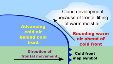
Cold Front
A cold front forms where a cold air mass moves into a warm air mass. Cold air contracts, becomes more dense, and thus heavier than warm air, so the cold air pushes underneath the warm air.
What happens at a cold front?
- Cumulus clouds, showers, thunderstorms may be scattered
- As the front passes, the wind changes direction. Skies begin to clear, and the temperature usually drops.
http://www.nauticed.org/images/excerpts/cold-front-advance.jpg
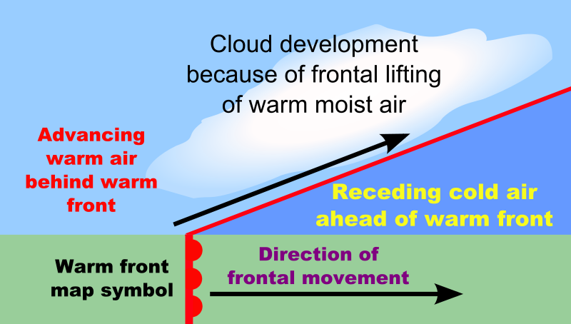
Warm Front
A warm front forms where a warm air mass moves into a cold air mass. Because the warm air is less dense, it slides up and over the colder air.
What happens at a warm front?
-At first, cirrus clouds might appear. They may be followed by stratus clouds and some precipitation, either rain or snow.
- When the front passes, the sky clears and the air pressure rises. Temperatures also rise as warm air replaces cold air.
http://upload.wikimedia.org/wikipedia/commons/thumb/c/c4/Example_of_a_warm_front.svg/800px-Example_of_a_warm_front.svg.png
Stationary Front
Even though air masses often move, sometimes they don't, resulting in a stationary front.
What happens at a stationary front?
- Precipitation and weak winds usually occur in areas with stationary fronts.
http://library.thinkquest.org/C0125863/weather/image/front_stationary_en.gif
Predicting Weather
Meteorologists - scientists who monitor weather conditions.
How? They sample a wide network of weather stations and use satellite images to map out the positions of the large air masses circling the Earth. Since air masses interact in a relatively predictable way, meteorologists are able to predict weather patterns with some degree of accuracy.
Fronts indicate the character of prevailing weather systems
Geography - local weather is greatly influenced by geography.
Every weather prediction is based on the chance that the weather conditions will act together in a certain way. That’s why forecasts can be wrong! Patterns help meteorologists predict weather for a local area.
Patterns of weather:
- Most weather conditions across the United States move from west to east. Moving weather conditions are due to wind patterns across the earth.
- In any given place, a clue to tomorrow's weather may be found by looking at the weather of the area to the west.
- geographic features in your area such as large bodies of water and mountains can affect local weather.
Example1, if you live near the Atlantic Ocean, conditions to the east often influence your weather. And whether you live near the east coast or west coast, temperatures near the ocean may be higher than they are even short distances inland. The heat-holding ability of large bodies of water causes warming of the air along the coast. In a city such as Chicago, which is located on Lake Michigan, forecasters often give two sets of information: one for people living within 5-10 miles of the lake, and the second for people in outlying areas. In the spring, for example, it's generally warmer in the outlying areas than it is closer to the lake.
Example 2, People who live on the eastern side of a mountain range such as the Sierra Nevadas have mostly dry weather. Even when moisture-laden air masses move into the area, their interaction with the mountains causes most of the moisture to fall on the western slopes.
So keep in mind that you can't just look at a weather map and expect to make totally accurate predictions. Lots of factors affect what happens in an area on any given day.
For geography, remember these five points:
1. Coastal areas have more moderate temperatures than inland areas, and are generally warmer in the winter and cooler in the summer.
2. In hilly areas, hot air moves up the slopes during the day and down the slopes at night.
3. High altitude areas are usually colder and receive more precipitation than low altitude areas.
4. The air above cities is often warmer than the surrounding area. In certain situations, this can create an artificial low-pressure system.
5. In costal areas, cool air usually blows inland during the day and out to sea at night.
Tools We Use for Weather Prediction
While the National Weather Service uses sophisticated equipment such as Doppler radar and high-altitude balloons to collect data, you can use many of the same tools they use.
Barometer - measure the air pressure, which is sometimes referred to as barometric pressure. The pressure of the air on the pool of mercury in the barometer causes the mercury to rise in a tube. We measure the height of mercury in the tube in inches. Therefore, air pressure is often stated in inches of mercury.
http://z.about.com/d/weather/1/0/-/1/-/-/Barometer.gif
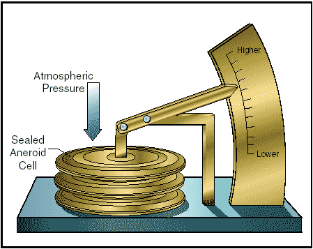
Aneroid barometers - don't contain mercury but have a small box inside instead. The air pressure on this box causes it to change shape, moving a needle on a gauge that indicates the air pressure.
Normal air pressure readings vary from 28 to 31.
Quick changes in air pressure often mean a change in the weather is about to occur. That's why you'll often hear and read about barometric pressure during local weather reports.
http://www.free-online-private-pilot-ground-school.com/images/aneroid-barometer.gif
Anemometer- measure wind speed - The device swings into the wind, and then the propeller blades rotate with the increasing wind speed.
But…. you can estimate wind speed just by looking around.
How? Watch how smoke rises in chimneys, how leaves move in trees, and how flags wave in the wind. Sailors and other people sometimes rate their observations of wind speed according to the Beaufort scale.
Beaufort scale - In 1805, the British Admiral Sir Francis Beaufort devised an observation scale for measuring winds at sea. The Beaufort Scale measures winds by observing their effects on sailing ships and waves. Beaufort's scale was later adapted for use on land and is still used today by many weather stations.
http://www.josephdecarlo.com/wp-content/uploads/beaufort_scale.gif
Look at the diagrams below. Each represents one level on the Beaufort scale.
http://www.ussartf.org/predicting_weather.htm
Wind Vane - While anemometers measure how fast the wind is blowing, wind vanes tell you from which direction the wind is blowing.
Why is this important?
Because knowing where the wind is coming from might give you clues to the temperature and the amount of water in the air moving into an area. For example, winds from the south are often warmer and carry more moisture than winds from the north. http://school.discoveryeducation.com/lessonplans/images/activities/weatherstation/windvane.jpg
Thermometer- measures the air temperature via the expansion or contraction of a liquid or a metal as the air temperature changes. Some thermometers contain red-colored alcohol, others contain mercury, while still others have a bimetal coil attached to a gauge.
In the United States, temperature is measured using two scales:
1. Fahrenheit scale, on which water freezes at 32 degrees and boils at 212 degrees.
Scientists and other people who regularly use metric measurements measure temperature on the Celsius scale, on which water freezes at 0 degrees and boils at 100 degrees.
Rain Gauge - simple instruments used to measure the amount of liquid precipitation. Any open container with a flat bottom and straight sides will work just by adding a scale of inches to it. Other kinds of precipitation are usually recorded by collecting the precipitation in a similar instrument, then letting the precipitation melt to find out the liquid equivalent. But at home, you might just want to use a ruler or yardstick to measure a deep snowfall! Then you can use the average conversion of 10 inches of snow equals 1 inch of rain to find out how much water fell.
http://images.google.com/imgres?imgurl=http://etc.usf.edu/clipart/44500/44591/44591_thermo_lg.gif&imgrefurl=http://etc.usf.edu/clipart/44500/44591/44591_thermo.htm&usg=__8lnUy0uJ3IHkn7a9B_tJi29Y8yk=&h=700&w=146&sz=22&hl=en&&sig2=hrmw_M_HbGeuEKIViAO0xw&um=1&itbs=1&tbnid=nNDFxbbFCynl-M:&tbnh=140&tbnw=29&prev=/images%3Fq%3DThermometer%26start%3D18%26um%3D1%26hl%3Den%26client%3Dsafari%26sa%3DN%26rls%3Den%26imgtbs%3Dt%26imgtype%3Dclipart%26as_st%3Dy%26ndsp%3D18%26tbs%3Disch:1&ei=QVumS4O5L8OBlAe9n6R2
http://www.icrisat.org/vasat/learning_resources/weather/html/m3l1/resources/m3/m3a/m3b/p4.JPG
Weather Phenomena
Thunderstorms and Lightning -
Thunderstorms occur when large air masses rise quickly into the atmosphere, forming huge cumulonimbus clouds.
Severe air currents inside the clouds cause water droplets and ice crystals to crash into one another continually, and the friction between these particles creates static electricity in the cloud. Over time, opposite charges build between the top and bottom of the cloud, and the bottom of the cloud and the earth. When these opposing charges become intense, a gigantic spark occurs (lightning) which jumps the gap between the cloud and the earth. The thunder accompanying lightning is the noise produced by the discharge.
Hurricanes -
Hurricanes are high speed windstorms accompanied by torrential rains.
They begin over the ocean where air rising from warm seas creates a severe low pressure zone. This zone draws air to it with such force the winds rotate around the core (the eye) at up to 185 mph. The 'eye' averages about 20 miles in diameter while the hurricane may be up to a few hundred miles in diameter. After the onset of a hurricane at sea, the storm moves slowly toward one of the poles and loses force as it moves into cooler areas or over land. Hurricanes are usually predicted by meteorologists well in advance of their occurrence.
Tornadoes -
One of the most destructive natural phenomena, tornadoes are swirling winds that spin at phenomenal speeds of up to 400 mph.
Like hurricanes, they are caused by severe low pressure zones that attract winds with force. They have relatively small bases, a fact which greatly magnifies their destructive power. Tornadoes are difficult to predict and often strike without warning. Meteorologists expect to be able to predict a tornado in the near future.
Waterspout -
Waterspouts are tornadoes over water which draw up large columns of water. If a waterspout moves from sea to shore, expect fish and other sea creatures to rain down!
Dust Devil -
Dust Devils' are small tornadoes over land that draw up dust and light debris. They are most common in desert area
Weather - the condition of the atmosphere. It can change from time to time and place to place.
Weather simply refers to the condition of the air on earth at a given place and time - whether it is warm or cold, dry or wet, blowing or calm. The condition of air and how it acts to create weather is influenced primarily by two things - heat (the sun) and water.
Weather on earth starts with the sun. The sun's heat warms our atmosphere and causes two things to happen:
1. water evaporates into the air
2. air rises
As air rises, its temperature drops. As the moisture in the air cools, it condenses into tiny suspended droplets, forming clouds. The droplets inside the clouds become larger as more moisture is evaporated into the air. Eventually, they are too heavy to remain suspended and fall to earth as precipitation - rain, snow, sleet or hail.
http://www.weather.gov/view/largemap.php
Climate - the type of weather an area has over a long period of time.
Weather may change on a daily basis, but climate changes over geologic time.
The factors that affect weather
Atmospheric Variables- things that can be measured and change from moment to moment.
1. Temperature - the average kinetic energy of a substance. The faster its molecules move the higher the temperature
The heat of the atmosphere is largely influenced by the sun and the degree to which it warms the air, land and oceans. The land and water retain heat and continue to heat the atmosphere after the sun disappears. Air temperature is measured with thermometers.
2. Air Pressure - the force exerted against a surface by the weight of air above that surface in the Earth's atmosphere.
High and Low Air Pressure
Certain weather conditions are associated with high and low pressure systems.
High Pressure Areas
- shown by "H" symbols.
- air pressure is greater than the surrounding areas.
- difference in air pressure results in wind, or moving air.
- air is more dense than in areas of lower pressure, air will move from the high pressure area to an area of less density, or lower pressure.
- Winds blow away from high-pressure areas toward areas having lower air pressure.
Low Pressure Areas
- shown by "L" symbols.
- Winds tend to blow into low-pressure areas because air, like other gases, moves from areas of higher pressure into areas of lower pressure.
- As winds blow into a low, the air moves up. This upward flow of air can cause clouds and precipitation to form.
Air pressure is measured by barometers.
- Weather will improve when pressure increases
- Weather will worsen when pressure decreases
http://okfirst.mesonet.org/train/meteorology/Variables.html
3. Wind Speed - Is the sustained wind speed (in knots)
4. Wind Direction - Is the expected wind direction using 36 points of a compass.
http://www.nws.noaa.gov/forecasts/graphical/definitions/defineWindSpd.html
5. Humidity - The amount of water vapor in the air
Water Vapor and Humidity
Relative humidity - the amount of water in the air at a certain temperature compared to how much water the air can hold at that temperature.
Air, like all gases, expands at higher temperatures. So air can hold more water vapor at higher temperatures than it can at lower temperatures. The amount of humidity in the air affects how quickly water can evaporate from surfaces such as roads, lakes, even your skin!
For example, at an air temperature of 80 degrees, 60 percent humidity might be very comfortable. But at 90 percent humidity, sweat evaporates from your skin very slowly, and you feel hot and sticky.
6. Dew point - a measure of atmospheric moisture. The dew point is the temperature to which air must be cooled for saturation to occur.
7. Cloud Cover - refers to the fraction of the sky obscured by clouds when observed from a particular location
http://z.about.com/d/weather/1/0/R/-/-/-/cloudcover.gif
8. Precipitation - is any product of the condensation of atmospheric water vapor that is pulled down by gravity and deposited on the Earth's surface
The effects of wind and air currents on weather
Air is made up of molecules that are constantly in motion. As air warms up, the molecules start to vibrate and bump into each other, increasing the space around each molecule. Because each molecule uses more space for motion, the air expands and becomes less dense (lighter). In other words, the same number of air molecules occupy a larger space or the same sized space with increased air pressure.
The opposite effect happens when air cools. As the temperature drops, molecules move more slowly, taking up less room. The amount of space the air takes up shrinks, or reduces the air pressure.
Why does Hot Air Rise?
Warm air rises because it is less dense, and when it rises it becomes cooler.
Meteorology - science of weather - based on air rising & cooling
1. Rising air experiences a drop in temperature
2. The drop in temperature is a result of the decrease in atmospheric pressure at higher altitudes.
3. If the pressure of the surrounding air is reduced, then the rising air parcel will expand. The molecules of air are doing work as they expand. This will affect the parcel's temperature (which is the average kinetic energy of the molecules in the air parcel).
Adiabatic heating and cooling
- when an air parcel expands, its temperature drops.
- when an air parcel is compressed, its temperature rises.
- a change in temperature of the parcel of air without gain or loss of heat from outside the air parcel.
Adiabatic processes are very important in the atmosphere, and adiabatic cooling of rising air is the dominant cause of cloud formation.
What makes the wind blow?
When warm air rises, cold air moves in replacing the warm air.
Wind -
1. air moving horizontally
2. created by large scale differences in the air's density
3. forces the air to move toward regions of lower pressure
If you stand with your back to the wind, an area of low pressure would be off to your left and the high pressure off to your right. The greater the differences in pressure, the stronger the wind
Why is wind important to weather?
If there wasn't any wind, there would be little or no day-to-day change in our weather.
Fronts and Air Masses
Air mass - a very large body of air that has similar properties. Air masses move, so they can be tracked over time. They are clues to the future temperature, moisture level and air pressure of the area into which they are moving.
Front - A boundary between two air masses
How does a front form?
When one air mass meets another, the air in different masses usually do not mix because the properties of the air masses are different. Stormy weather often occurs along fronts.
Cold Front
A cold front forms where a cold air mass moves into a warm air mass. Cold air contracts, becomes more dense, and thus heavier than warm air, so the cold air pushes underneath the warm air.
What happens at a cold front?
- Cumulus clouds, showers, thunderstorms may be scattered
- As the front passes, the wind changes direction. Skies begin to clear, and the temperature usually drops.
http://www.nauticed.org/images/excerpts/cold-front-advance.jpg
Warm Front
A warm front forms where a warm air mass moves into a cold air mass. Because the warm air is less dense, it slides up and over the colder air.
What happens at a warm front?
-At first, cirrus clouds might appear. They may be followed by stratus clouds and some precipitation, either rain or snow.
- When the front passes, the sky clears and the air pressure rises. Temperatures also rise as warm air replaces cold air.
http://upload.wikimedia.org/wikipedia/commons/thumb/c/c4/Example_of_a_warm_front.svg/800px-Example_of_a_warm_front.svg.png
Stationary Front
Even though air masses often move, sometimes they don't, resulting in a stationary front.
What happens at a stationary front?
- Precipitation and weak winds usually occur in areas with stationary fronts.
http://library.thinkquest.org/C0125863/weather/image/front_stationary_en.gif
Predicting Weather
Meteorologists - scientists who monitor weather conditions.
How? They sample a wide network of weather stations and use satellite images to map out the positions of the large air masses circling the Earth. Since air masses interact in a relatively predictable way, meteorologists are able to predict weather patterns with some degree of accuracy.
Fronts indicate the character of prevailing weather systems
Geography - local weather is greatly influenced by geography.
Every weather prediction is based on the chance that the weather conditions will act together in a certain way. That’s why forecasts can be wrong! Patterns help meteorologists predict weather for a local area.
Patterns of weather:
- Most weather conditions across the United States move from west to east. Moving weather conditions are due to wind patterns across the earth.
- In any given place, a clue to tomorrow's weather may be found by looking at the weather of the area to the west.
- geographic features in your area such as large bodies of water and mountains can affect local weather.
Example1, if you live near the Atlantic Ocean, conditions to the east often influence your weather. And whether you live near the east coast or west coast, temperatures near the ocean may be higher than they are even short distances inland. The heat-holding ability of large bodies of water causes warming of the air along the coast. In a city such as Chicago, which is located on Lake Michigan, forecasters often give two sets of information: one for people living within 5-10 miles of the lake, and the second for people in outlying areas. In the spring, for example, it's generally warmer in the outlying areas than it is closer to the lake.
Example 2, People who live on the eastern side of a mountain range such as the Sierra Nevadas have mostly dry weather. Even when moisture-laden air masses move into the area, their interaction with the mountains causes most of the moisture to fall on the western slopes.
So keep in mind that you can't just look at a weather map and expect to make totally accurate predictions. Lots of factors affect what happens in an area on any given day.
For geography, remember these five points:
1. Coastal areas have more moderate temperatures than inland areas, and are generally warmer in the winter and cooler in the summer.
2. In hilly areas, hot air moves up the slopes during the day and down the slopes at night.
3. High altitude areas are usually colder and receive more precipitation than low altitude areas.
4. The air above cities is often warmer than the surrounding area. In certain situations, this can create an artificial low-pressure system.
5. In costal areas, cool air usually blows inland during the day and out to sea at night.
Tools We Use for Weather Prediction
While the National Weather Service uses sophisticated equipment such as Doppler radar and high-altitude balloons to collect data, you can use many of the same tools they use.
Barometer - measure the air pressure, which is sometimes referred to as barometric pressure. The pressure of the air on the pool of mercury in the barometer causes the mercury to rise in a tube. We measure the height of mercury in the tube in inches. Therefore, air pressure is often stated in inches of mercury.
http://z.about.com/d/weather/1/0/-/1/-/-/Barometer.gif
Aneroid barometers - don't contain mercury but have a small box inside instead. The air pressure on this box causes it to change shape, moving a needle on a gauge that indicates the air pressure.
Normal air pressure readings vary from 28 to 31.
Quick changes in air pressure often mean a change in the weather is about to occur. That's why you'll often hear and read about barometric pressure during local weather reports.
http://www.free-online-private-pilot-ground-school.com/images/aneroid-barometer.gif
Anemometer- measure wind speed - The device swings into the wind, and then the propeller blades rotate with the increasing wind speed.
But…. you can estimate wind speed just by looking around.
How? Watch how smoke rises in chimneys, how leaves move in trees, and how flags wave in the wind. Sailors and other people sometimes rate their observations of wind speed according to the Beaufort scale.
Beaufort scale - In 1805, the British Admiral Sir Francis Beaufort devised an observation scale for measuring winds at sea. The Beaufort Scale measures winds by observing their effects on sailing ships and waves. Beaufort's scale was later adapted for use on land and is still used today by many weather stations.
http://www.josephdecarlo.com/wp-content/uploads/beaufort_scale.gif
Look at the diagrams below. Each represents one level on the Beaufort scale.
http://www.ussartf.org/predicting_weather.htm
Wind Vane - While anemometers measure how fast the wind is blowing, wind vanes tell you from which direction the wind is blowing.
Why is this important?
Because knowing where the wind is coming from might give you clues to the temperature and the amount of water in the air moving into an area. For example, winds from the south are often warmer and carry more moisture than winds from the north. http://school.discoveryeducation.com/lessonplans/images/activities/weatherstation/windvane.jpg
Thermometer- measures the air temperature via the expansion or contraction of a liquid or a metal as the air temperature changes. Some thermometers contain red-colored alcohol, others contain mercury, while still others have a bimetal coil attached to a gauge.
In the United States, temperature is measured using two scales:
1. Fahrenheit scale, on which water freezes at 32 degrees and boils at 212 degrees.
Scientists and other people who regularly use metric measurements measure temperature on the Celsius scale, on which water freezes at 0 degrees and boils at 100 degrees.
Rain Gauge - simple instruments used to measure the amount of liquid precipitation. Any open container with a flat bottom and straight sides will work just by adding a scale of inches to it. Other kinds of precipitation are usually recorded by collecting the precipitation in a similar instrument, then letting the precipitation melt to find out the liquid equivalent. But at home, you might just want to use a ruler or yardstick to measure a deep snowfall! Then you can use the average conversion of 10 inches of snow equals 1 inch of rain to find out how much water fell.
http://images.google.com/imgres?imgurl=http://etc.usf.edu/clipart/44500/44591/44591_thermo_lg.gif&imgrefurl=http://etc.usf.edu/clipart/44500/44591/44591_thermo.htm&usg=__8lnUy0uJ3IHkn7a9B_tJi29Y8yk=&h=700&w=146&sz=22&hl=en&&sig2=hrmw_M_HbGeuEKIViAO0xw&um=1&itbs=1&tbnid=nNDFxbbFCynl-M:&tbnh=140&tbnw=29&prev=/images%3Fq%3DThermometer%26start%3D18%26um%3D1%26hl%3Den%26client%3Dsafari%26sa%3DN%26rls%3Den%26imgtbs%3Dt%26imgtype%3Dclipart%26as_st%3Dy%26ndsp%3D18%26tbs%3Disch:1&ei=QVumS4O5L8OBlAe9n6R2
http://www.icrisat.org/vasat/learning_resources/weather/html/m3l1/resources/m3/m3a/m3b/p4.JPG
Weather Phenomena
Thunderstorms and Lightning -
Thunderstorms occur when large air masses rise quickly into the atmosphere, forming huge cumulonimbus clouds.
Severe air currents inside the clouds cause water droplets and ice crystals to crash into one another continually, and the friction between these particles creates static electricity in the cloud. Over time, opposite charges build between the top and bottom of the cloud, and the bottom of the cloud and the earth. When these opposing charges become intense, a gigantic spark occurs (lightning) which jumps the gap between the cloud and the earth. The thunder accompanying lightning is the noise produced by the discharge.
Hurricanes -
Hurricanes are high speed windstorms accompanied by torrential rains.
They begin over the ocean where air rising from warm seas creates a severe low pressure zone. This zone draws air to it with such force the winds rotate around the core (the eye) at up to 185 mph. The 'eye' averages about 20 miles in diameter while the hurricane may be up to a few hundred miles in diameter. After the onset of a hurricane at sea, the storm moves slowly toward one of the poles and loses force as it moves into cooler areas or over land. Hurricanes are usually predicted by meteorologists well in advance of their occurrence.
Tornadoes -
One of the most destructive natural phenomena, tornadoes are swirling winds that spin at phenomenal speeds of up to 400 mph.
Like hurricanes, they are caused by severe low pressure zones that attract winds with force. They have relatively small bases, a fact which greatly magnifies their destructive power. Tornadoes are difficult to predict and often strike without warning. Meteorologists expect to be able to predict a tornado in the near future.
Waterspout -
Waterspouts are tornadoes over water which draw up large columns of water. If a waterspout moves from sea to shore, expect fish and other sea creatures to rain down!
Dust Devil -
Dust Devils' are small tornadoes over land that draw up dust and light debris. They are most common in desert area
